Saturday, March 13, 2021

THE NEOLATIN BRIDGE BETWEEN ITALY AND ROMANIA

 The historical "bridge" between Romanians and Dalmatian Italians


There was a continuum of romance speaking populations in Europe at the end of the Western Roman Empire, from Portugal and Spain to France and Italy: this continuum reached the Balkans until the Danube river delta, from Italian Istria until the Romanian Dobrugia.

But actually there it is a "hole" of this continuum in the area that was former Yugoslavia (Slovenia, Croatia, Bosnia-Herzegovina and Serbia), because of the Slav invasions that happened during the early Middle Ages. However for many centuries this hole between Italy and Romania was partially occupied by a kind of "bridge" of neolatin populations (usually called "Vlachs", a word from latin 'vallum', meaning 'people of the Roman vallum' near the barbarian borders of the Western Roman empire) during the late Middle Ages until the Renaissance centuries. These Vlachs lived in the mountains of the western Balkans, but were slowly "assimilated" by the Slavs and actually they have practically disappeared, leaving only some evidences of themselves in the names of the Balkan topography & history (like "Romanija", "Stari Vlah", etc..).

Map showing the remains of the "Bridge" (Romanija Planina & Stari Vlah) in the XIII century, between the neolatin territories of Ragusa Republic & Spalato of the Dalmatian Italians and those of the Valko (Vojvodina) & Kucso (Timok)


Indeed Ilona Czamańska wrote in "Vlachs and Slavs in the Middle Ages and Modern Era” (Res Historica, 41, (Lublin, 2016), 19) that: "The majority of Serbs from the Republika Srpska of modern Bosnia is of Vlach origin, as well as the majority of the population from Bosnia and Herzegovina in general." This fact is clearly related to the historical bridge -now disappeared- that existed until the Middle Ages between the romance speaking Romanians and the Italian populations in Dalmatia and Istria.

The following are excerpts -related to this "bridge"- from an essay written by Octavian Ciobanu (Professor of Iasu University) and titled "The Heritage of Western Balkan Vlachs":

A lot of Latin or Vlach place names still resist until today in Western Balkans. Jirecek wrote about the Vlach impressive presence in Montenegro, Herzegovina and Dalmatia in a period which lasted from the XIIIth to the XVIth centuries.The Serbian documents from the 12th to the 15th centuries revealed a large number of Vlach placenames and Vlach personal names which are still in use by the Slavs of the Western Balkans. The Romanian character of the language of these Vlachs is generally recognized.

According to Stelian Brezeanu, among the toponyms attesting the presence of the Romanic element in the region, there are two that have an importance: Palaioblacoi and Stari Vlah. Palaioblacoi is attested in Thessaly (later Μεγάλη Βλαχία/Megali Vlahia) and the second toponym, Stari Vlah, is attested in the Medieval Serbia and in Herzegovina: “It was a region inside of the Kingdom of the Nemanids that attached the Kopaonik Mountains to the Romanija Mountains, around the city of Sarajevo. That region had as centre the Drina and the Lim rivers valley.”

Next to Stari Vlah it is Romanija. This area has the mountain still called Romanja.Therefore, the region of Stari Vlah belonged to a more extended area, intensively romanised at the end of the antiquity.Ştefan Stareţu writes that “it is clear that Stari Raska comes from Stari Vlaska, with a rothacism, and Raska from Vlaska (this is exemplified by the double name of Banat, as Vlaska or Raska)”. He also advances a hypothesis: “The Serbs and Vlachs are probably a single ethnic substance, constructed in the Balkan Peninsula as a unity in the 8th-14th century.”


Furthermore, according to Ilona Czamańska the Vlach population was already established in the western Balkans during the migration of Slavs. But she pointed out that both ethnic groups occupying the same land were not in conflict. Slavs, as farmers, occupied lands in the valleys, which were suitable for them, while Vlachs exploited mountains. Slavs, next to agriculture, also engaged in breeding, but did not practice transhumance pastoralism, which was the domain of the Vlachs. For the Slavs the land and the right to its cultivation and ownership was most important, for the Vlachs the ownership of land did not matter as long as the mountains were common property. The element, which bound their community together, was not the land, but family relationships and the sense of belonging to the same "clan".

In the Middle Ages the Vlachs lived in most of the mountain areas in the western Balkans up to the Adriatic coast. In the Middle Ages, the territory between the rivers Lim and Drina in the west, and Raska and Studenica in the east, was called “Old Wallachia” (Stari Vlah), and the Orthodox Church province of the Rasca – “eparchy Old Wallachian”.

In the Serbia of the Nemanjić dinasty (1166-1371) and the states that have later arisen on its ruins, the Vlachs created a fairly closed community because of their special privileged status, in contrast to the rest of Slavic peasant population. Mixed marriages with representatives of other social classes, especially the peasant population, were very difficult here. Despite that, here the processes of Slavisation and assimilation proceeded very quickly. It was also facilitated because of the vanishing of the areas where the Vlach shepherds could wander, because of the distribution of the mountain areas to particular owners. Vlachs defended themselves against dependence for example by buying pastures, which resulted in their definitive transition to semi-sedentary and sedentary life.

The Knez and provincial governors (often Vlach ones) became major landowners, entering the group of nobles and even the aristocracy of Serbia. Among the Slavic Balkan rulers many had Vlach roots – most probably the families Balšić, Hrvatinić – Kosača, and perhaps also Mrnjavcević. Already the earliest records of the names of the Vlachs as well as the names of localities preserved in the sources of the 13th century show a hybrid combination of Vlach and Slav element. Even then, many Vlach names were Slavic, often with Romanian endings (i.e. Dragul, Radul and Bogdan and afterwards even Milutin, Vukašin and Momcil).

Starting from the 14th century the term “Vlach” began to lose its ethnical meaning in favour of a societal meaning in the areas of Serbia and Bosnia and Herzegovina. In these areas the Vlachs were strongly mixed with the Slavic population and the name “Vlach” was frequently used interchangeably with the term “Slav”.

In the "bridge", Slavisation (in fact Serbisation) of the Vlachs was also encouraged by the period of the Ottoman rule. As Orthodox, Vlachs belonged to the same millet as Serbs, and after the reconstruction of the Serbian Patriarchate of Peć they were subordinated to civil authority of the Serbian patriarch. Thus, Vlachs were integrated with Serbs very quickly, especially that the religious affiliation was the main identifier. The persons who belonged to the Serbian Orthodox Church were called by the name of Serbs, not only in the lands which were traditionally Serbian, also in Bosnia. This process was intensified by the fact that many Vlachs abandoned their activities, especially since enclosed social classes did not exist in the Ottoman state.

Actually -according to Marian Wenzel- the majority of the population from Bosnia and Herzegovina in general is of Vlach origin.

Map showing the location (with small points) of the 'Stecci', medieval funerary monuments, in an area that is very similar to the one of the "historical bridge". Note that the easternmost 'Stecci' are located in Serbia's "Stari Vlah" and the westernmost are near the Republic of Venice's Zara area (linking -as a kind of "bridge" through Serbia and Bosnia/Herzegovina- western Romania and Italy's Dalmatia)


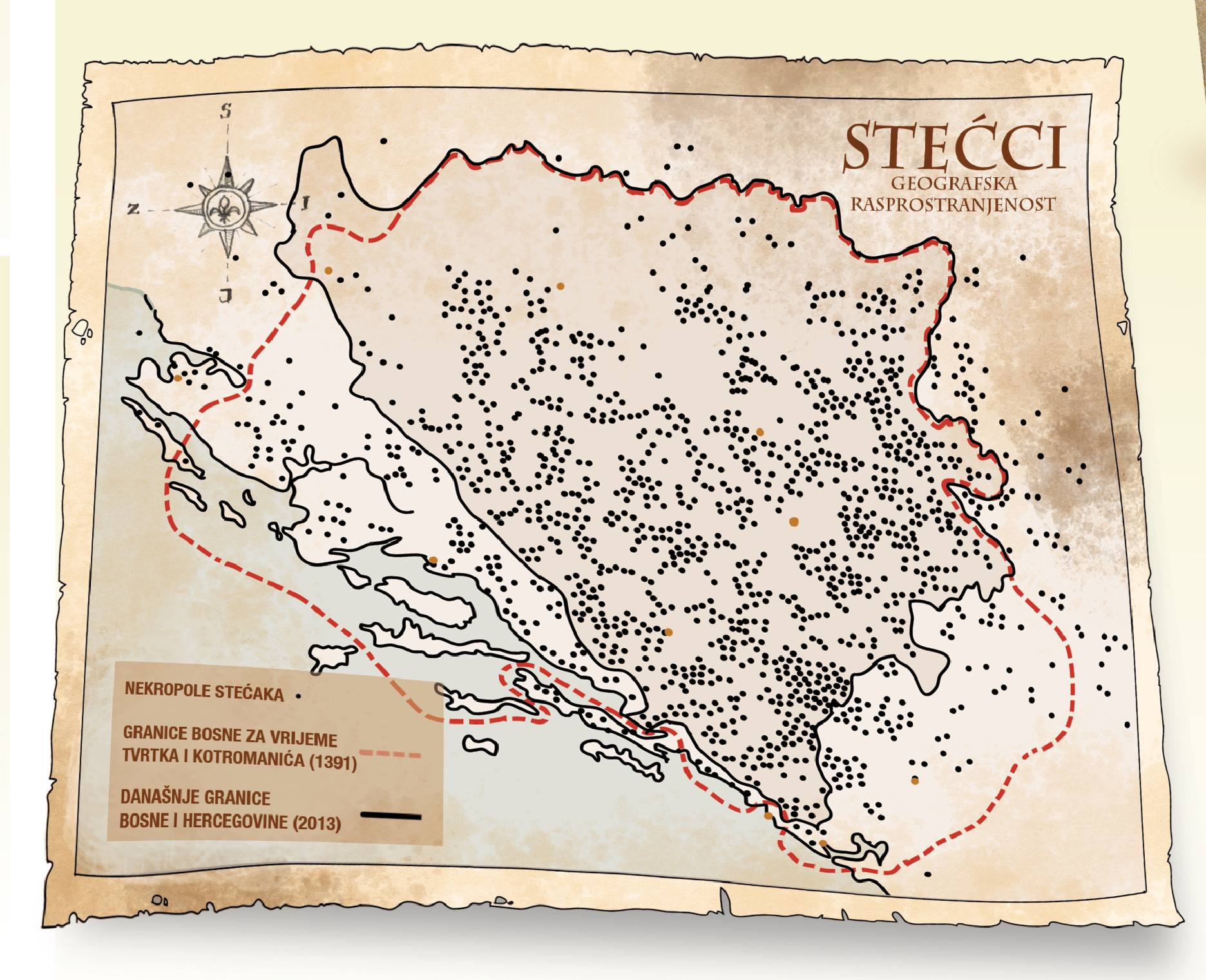
Indeed the medieval Vlachs (called often Aromanians) of Herzegovina are considered authors of the famous funerary monuments with petroglyphs (usually called "Stecci") from Herzegovina and surrounding countries. The theory of the Vlach origin of these 'Stecci' was proposed by Bogumil Hrabak (1956) and Marian Wenzel and more recently was supported by the archeological and anthropological researches of skeleton remains from the graves under these 'Stećci'. For Wenzel the Vlachs did not continue to create other 'Stecci' since their conversion -in the sixteenth century- to moslem religion because of Turks domination.

The theory is much older and was first proposed by Arthur Evans in his work "Antiquarian Researches in Illyricum" (1883): while doing research with Felix von Luschan on 'Stecci' graves around Konavle, he found that a large number of skulls were not of Slavic origin but similar to older romanised Illyrian population, as well as noting that Ragusa memorials recorded those parts inhabited by the Vlachs until the 15th century. In other words: these 'Stecci' made by neolatins confirm the existence of this "bridge" betweeen Dalmatia and "Stari Vlah"

Last but not least, we have to remember that in the area of southern Croatia and internal Dalmatia these Vlachs -who were present in the early Middle Ages- were called 'Maurovlachs', or 'Morlachs'(Morlacchi) by the Italians, and they relatively quickly succumbed to Slavisation and Catholic faith. They differentiated themselves from the rest of society through their social status, which took on a special meaning in these lands. In the 17th and 18th centuries the term 'Morlachs' determined both Slavisised Vlachs from the area of Dalmatia, as well as Croatian peasants who were mixed with Dalmatian Italians (and who actually speak a croatian dialect -called "Chacavian"- that has more than 50% of words loaned from latin & romance languages).

Map showing the actual 'neolatin gap' between Italy and Romania, that from Istria & Dalmatia reached western Romania's Timok region trough Herzegovina, Romanija and Stari Vlah.

In a few final words: The neolatin "bridge" (between Italy and Romania) existed from the barbarian invasions until the first Renaissance centuries, remaining in a few isolated mountain areas until the XVIII century: it seems to have disappeared with the end of the "Repubblica di Venezia" and the beginning of the 'nationalism' in the Balkans. But if we include in the "bridge" also the Dalmatian Italians of coastal Dalmatia, we must remember that the last speaker of this autochtonous Dalmatian language (Tuone Udaina) died in 1898 in Veglia (actual Krk) and so the "bridge" remains survived in some way until the XIX century's end.

However -according to Italian historians like Della Volpe- a legacy of this "bridge" can be seen in the existence of the Republic of Bosnia & Herzegovina, populated mainly by descendants of the romanised populations who created the worldwide famous "Stecci" (read for further information on the Stecci: https://www.scribd.com/doc/34362364/Marian-Wencel-UKRASNI-MOTIVI-NA-STE%C4%86CIMA ).

Saturday, November 7, 2020

MAY 1941: SOUTHERN SLOVENIANS WELCOMED THEIR UNION TO ITALY

The following is an essay about the 1941 months when Southern Slovenia was united to the Kingdom of Italy, while many Slovenians welcomed the creation of the "Provincia italiana di Lubiana " (Ljubljana Italian Province). The essay was written by B. D'Ambrosio of the "Universita' Statale di Genova" (University of Genova - Italy):


SPRING/SUMMER 1941:WHEN THE ITALIANS WERE WELCOMED IN SOUTHERN SLOVENIA

Many forget that the Italian troops were welcomed even with enthusiasm in some territories of Yugoslavia, when Italy (together with Germany) defeated Yugoslavia in April 1941. Unfortunately this "special idyll" between Italians and Slavic populations did not last long, beginning to deteriorate after the Axis attack on Stalin's Soviet Union in June 1941.

Obviously it should be noted that the followers of the Yugoslav king Peter II were almost the only ones who "really" fought against the Italian troops, even if only in Montenegro there was a serious and strong opposition. General Roatta reported in his 'Memories' that "all available forces in northern Italy gathered at the Yugoslav frontier between Tarvisio and Fiume in early March 1941: two armies on the front line, and a third in reserve. Altogether there were thirty-seven divisions, eighty-five groups of medium-caliber artillery, and all the special formations, with corresponding services and supplies".

Representatives of Slovene political parties with the Italian High Commissioner Emilio Grazioli (with military dress) on May 3, 1941. The first to Grazioli's right is Marko Zlatacen
General Ambrosio's troops broke through the yugoslav lines of defense with relative ease in Zara and Venezia Giulia and in a couple of days they arrived in Lubiana and Spalato in what was propagandistically called the "Italian blitzkrieg", making many prisoners of war while were also welcomed by many Croats who greeted them because they wanted independence from the Serbs.

Equally favorable were the Albanian populations in the southern Yugoslavia territories that were conquered by the Italians and which were subsequently united with "Italian Albania". And almost the same happened in Montenegro and southern Slovenia, at least initially.

But it was the Serbs of northern coastal Yugoslavia who most "liked" the Italian presence in those lands, especially after the surrender of the Yugoslav kingdom and the rise to power of the immediately created "independent state of Croatia" ('Nezavisna Država Hrvatska', abbreviated in NDH) of Ante Pavelic's "Ustascia". In fact the fascist Pavelic, who came to power after 10 April with the declared support of Mussolini (who had helped him for many years: read for more information my 2015 paper, translating it from Italian language http://brunodam.blog.kataweb.it/2015/06/01/quando-la-croazia-sembrava-poter-essere-italiana/), had arrived in Zagreb early in the morning of April 15, leading a few hundred followers dressed in Italian uniforms to become the "Poglavnik" (the Croatian equivalent of "Duce"). Its first "Legal Ordinance for the Defense of the People and the State", dated April 17, 1941, prescribed the death penalty for the breaking of the honor and vital interests of the Croatian people and the survival of the Independent State of Croatia ": it was a clear omen of what would happen in its territories.

Indeed, the Ustascia immediately began to conduct a deliberate campaign of massacres, deportations and forced religious conversions in an attempt to remove the unwanted from their territory: Serbs, Jews, Gypsies, Croatian dissidents and others. The atrocities against non-Croats began on April 27, 1941, when a new unit of the Ustascia army massacred the Serbian community of Gudovac, near Bjelovar. Some days later another massacre happened at Kosinj, in the Lika region. When the Italians knew of these massacres, they strongly rejected what has been done: it was the first 'fracture' between Mussolini and Pavelic

More than a month after the creation of the NDH, the anti-fascist movement emerged in 1941 occupied Yugoslavia mainly under the command of the Communist Party, led by Josip Broz Tito. Slovenian and Croatian partisans (partizans) began what would be recognized as the 'War of Yugoslav Liberation' on June 22, 1941 (shortly after the German attack on the Stalin's Soviet Union), when their first armed unit was formed in Brezovica, near Sisak. The partisans engaged in combat for the first time on June 27 in the Lika region.

Postcard of Lubiana under Italian control in summer 1941
But in Slovenia for more than 3 months - after the defeat of Yugoslavia in April 15 and until the end of July - there was a "relatively quiet" peace without anti-Italian resistance, initially supported by the Slovenes who today are generically called "Domobranci" (Slovenian anti-communists). In August and September there were some sabotages, but only on October 1941 there was the first military action of Italian troops against the Slovenian resistance, when two Tito partizans were killed

At the same time in southern Slovenia nearly 20,000 Slovenians collaborated with the Italians (as members of anticommunist organizations, from "Civic Guards" to "BelaGardists").

The welcome to the Italians

As we all know, Yugoslavia was divided between areas of influence/occupation "(that of Italy, Germany, Bulgaria and Hungary). The Italian presence took place in four regions of its area, populated mainly by: Slovenes, Croats, Montenegrins and Albanians. The Slovenian one was special, because the "Provincia di Lubiana" was created as an attempt to assimilate/integrate this area into Fascist Italy.

Emilio Grazioli was made by Mussolini the main Italian authority in Lubiana: his nomination was welcomed by many slovenian leaders, from Marko Natlacen (the last Governor of the Yugoslavia's "Drava Banovina") and Juro Adlesic (mayor of Lubiana) to Leon Putnik (general & anti-communist politician) and Gregory Rozman (bishop of Lubiana).

Lubiana, April/22/1941. From left: Ignacij Nadrah,Emilio Grazioli,Gregorij Rožman,Frank Kimovec


Furthermore, it is noteworthy to pinpoint that some slovenians were grateful to the Italians because of the 1941/1942 removal of the German speaking population of the so called "Gottschee" in the southernmost area of Slovenia: it was the same kind of agreement between Mussolini and Hitler that was done for the Germans in Italy's Alto Adige. Since then the Gottschee area has been a fully Slovene territory.

SLOVENIA ITALIANA

The southern part of Slovenia which was occupied by the Italians was annexed to the Kingdom of Italy on May 3, 1941, with the official name: "Provincia italiana di Lubiana" ('Italian province of Ljubljana') with 4545 km2 and 337,000 inhabitants (nearly 80,000 in Lubiana). This province, which took its name from the capital Lubiana (the Roman "Emona"), was in fact partially administered as an occupation zone. However there were no real attempts at Italianization (there were only 600 Italian civilians in all the 'Provincia'!), neither by the public administration (in which only some personnel from the mother-country were included) nor by the school (bilingualism was allowed) and cultural institutions (maintained and only in some cases accompanied by the fascist ones).

In addition, works were started by the Italian authorities in order to improve health services, public structures, electricity services and sewage systems in Lubiana & surroundings. A new huge & modern hospital was planned. Also, the railway service between Italian Slovenia and Trieste was improved; and the Polje airport in western Lubiana was greatly enlarged.

The Lubiana airport was greatly improved by the Italian Air Force
The high commissioner Emilio Grazioli initially carried out a moderate policy, in an attempt to involve the conservative business classes and the Catholic Church, giving life to a "Consulta", an assembly of local notables that was supposed to cooperate and support the work of the italian authorities. Indeed, the influential bishop of Lubiana, Gregorij Rožman, and most of the country's pre-war politicians, led by political leader Marko Natlačen, immediately expressed in early May 1941 their willingness to collaborate with the fascist authorities, writing public letters of support for the annexation of the province of Lubliana to Italy. On June 8, 1941, Natlačen led Slovenian politicians and industrialists to meet Mussolini in Rome, after which they reaffirmed their loyalty, and began to officially collaborate with the Italians in the 'Consulta', an advisory body.

In the days immediately following, 105 Slovenian mayors sent a message to Mussolini, expressing "joy and pride for the incorporation of Slovenian territories into the great Kingdom of Italy". A similar message of congratulations also reached the Duce from the archbishop of Lubiana, Gregorij Rozman. This catholic "vescovo" (together with Ignacj Nadrah and Frank Kimovec) became one of the most important collaborators of the fascist regime, guaranteeing the loyalty of large sections of the 'believing' catholic population.

Lubiana: Military parade of Italians on first week of April 1941, with slovenian civilians attending


The result of German harsh policy in the nazi occupied area north of Lubliana was the influx of tens of thousands of Slovenes into the Italian province. A few weeks after the end of the war against Yugoslavia, 27,000 people crossed the border between German and Italian Slovenia (17,000 settled in Lubiana). The Italian reports on these facts left no room for doubt about the causes of the exodus, identified in the German "inhuman yoke". Germany was accused of stripping Slovenian land and stripping the local population of the basis for their survival. In doing so, Berlin forced the population to seek a less "barbaric" place for its existence. And even in the final months of 1941 hundreds of Slovenians crossed the border between the two occupation zones to settle in the Italian territory. This created problems (of food, lodging, health assistance, etc..) to the Italian authorities, but showed to the Slovenians the "good side" of Italian presence in southern Slovenia.

However this continuous influx of people from the north was viewed with suspicion -after summer 1941- by the Italian administration, which feared that once they arrived, especially men, they could become a threat to the internal security of the province (because linked to Tito's partizans): according to general Roatta they were the main culprit of the guerrilla & terrorism attacks that destroyed the good relationships between Italians and Slovenians at the end of 1941/beginning of 1942 (M. Roatta, "Otto milioni di Baionette. L’esercito italiano in guerra dal 1940 al 1944". Mondadori. Milano, 1946).

Some historians pinpoint that the original population of Lubiana & southern Slovenia was going to behave in a relatively "quiet way" with the Italians, like happened in the Governorate of Dalmatia at least untl the end of 1942: it was people from northern Slovenia (and other areas of Iugoslavia) who enrolled in Tito's partizan groups and who created the fracture between Italians and local Slovenians, mainly after fall 1941!

Although very few, Slovenian fascists had made themselves known in Slovenian politics since the 1920s: in 1923 a small fascist party of Slovenes of Venezia Giulia ("Vladna Stranka", government party) was born, which then in 1925 merged into the 'Party National Fascist', and a certain amount of unemployed Slovenian youth joined the Fascist militia. In Lubiana in May 1941, immediately small groups of Slovenian fascists were created who obviously supported the union with the Kingdom of Italy (but only on 21 October 1941 the National Secretariat of the National Fascist Party established - on Mussolini's orders - the "Federation of Fascists of Combat of Lubiana ": Grazioli was appointed Federal Secretary).

After all, some Slovenes (fascists and non-fascists) immediately promoted the establishment of collaborationist armed bands, subsequently called MVAC (Voluntary Anti-Communist Militia) and integrated into small units in the Italian army. The MVAC had a decidedly notable importance in Slovenia, where some old adherents of the conservative pre-war parties, tightened around the highest ecclesiastical hierarchies and animated by a heated anti-communism, created a political-military structure that obtained a wide consensus and came to mobilize more than 6,100 men in 1941 and 1942. In fact, the Italian authorities immediately supported the anti-communist Slovenian political forces, especially of Catholic inspiration, which, fearing the communist revolution, had at that moment identified the greatest danger in the partisan communist movement, and had therefore made themselves available for collaboration.

These political forces had thus created "self-defense formations" (the most numerous was "Vaška Straža" and the most militant was "Legija Smrti" or 'Legion of Death' - the latter also called more commonly 'White Guard' or "Bela Garda") under the direct inspiration and coordination of the Bishop of Lubiana Gregorij Rožman. The Italian commands (under General Mario Roatta of the 2nd Italian Army) organized these formations -in the following August 1942-  in the "Anti Communist Voluntary Militia" or MVAC (new collective name hired by the pre-existing Slovenian organizations from 6 August 1942), using them successfully in the anti-partisan struggle.

Also worth mentioning is the "Civic Guard" ('Vaške Straže' or village guards), which was created in November 1941 by Ernst Peterlin. It was a militia of Slovenian Catholic peasants set up to prevent the robberies and assaults of the "Tito" communist partisans in the Slovenian countryside. The Civic Guard was also created (in the intentions of its leaders) to prevent the establishment of communist political and military power on Slovenian territory, with the ultimate aim of contributing to the establishment of a Catholic political system in the country.

The 'Civic Guard' (with dark berrets) of Rakitna -a village between Lubiana and Postumia- with Italian officers and some civilians & religious groups, in summer 1941
It should be noted that in addition to the approximately 6,100 of the MVAC, the Slovenian Catholic auxiliary forces deployed a total of 7,000 men alongside the Italian authorities at the end of 1941, when the communist resistance in Slovenia began to be present in a serious form (with attacks and murders): the idyll in Slovenia was over!

In fact, in December 1941 an Italian teacher was killed by the Slovenian Communists in front of her pupils in Lubiana (read for further informationhttps://books.google.com/books?id=SGCuAgAAQBAJ&pg=PA49&lpg=PA49&dq=uccisione+di+maestra+italiana+a+lubiana+nel+1941&source=bl&ots=ygJ_DFeepV&sig=ACfU3U3Yj0uJ0xTobF-TUmYVwjonIXFQew&hl=en&sa=X&ved=2ahUKEwjanuau8-LsAhWuxFkKHSo7DDIQ6AEwEnoECAEQAg#v=onepage&q=uccisione%20di%20maestra%20italiana%20a%20lubiana%20nel%201941&f=false). She was the first Italian civilian (and the first Italian woman) murdered by the Tito partizans in Slovenia, sparking the reaction of the Italian military authorities (who consequently -also because of this murder- enclosed with barbed wire fence all the city of Lubiana in January 1942).

In other words, this "special idyll" had been quite successful and even happy in the months of May and June 1941, but with the attack against Stalin's Soviet Union it began to disintegrate and by early 1942 it had completely vanished: it didn't even last one year!

Sunday, October 6, 2019

A ROMAN COLONY IN BRITANNIA: CAMULODUNUM (ACTUAL COLCHESTER)

There are many books & essays about Roman "Camulodunum", the actual Colchester in Great Britain - an important city not far away from London in the Essex region. The following is a study done for the University of Genova by Bruno D'Ambrosio, that I judge to be one of the best about this ancient Roman colony (because of simplicity and clear narrative with noteworthy impartiality):


A ROMAN COLONY IN BRITANNIA: CAMULODUNUM (COLCHESTER)


Romans created colonies for their veterans in the territories they conquered. Four were created in the British isles. The following essay is a brief research on one of these colonies in Roman Britannia: Camulodunum (actual Colchester).

The 1st century colonies at Camulodunum/Colchester (Colonia Claudia Victricensis), Lindum/Lincoln (Colonia Domitiana Lindensium), and Glevum/Gloucester (Colonia Nervia Glevensium) were founded as settlements for legionary veterans. The creation of three coloniae on the sites of earlier fortresses was a useful expedient whereby time-served legionaries could be discharged, form a military reserve, and receive their due grant of land with minimal disturbance of the native population.

Map showing the four colonies of veterans in Roman Britannia and the area Romanized & populated by the Romano-Britons around these colonies in 410 AD. Note that the 3 original colonies (Camulodunum-Glevum-Lindum) enclosed a perfect equilateral triangle, later expanded to the north with the creation of the veterans' colony of Eburacum by emperor Septimius Severus (when he tried the full conquest of Caledonia/Scotland in the third century)

In contrast, the sites of the fortresses at Exeter (Isca Dumnoniorum) and Wroxeter (Viroconium Cornoviorum) became tribal centers of the local Britons. 

The only other known Roman colonia in Britain, at Eboracum (York), is generally believed to have been promoted to this status in the early 3rd century.

It is noteworthy to remember that Tacitus wrote that in winter 84 AD all Britannia was fully conquered by the Romans: even all Caledonia/Scotland.

He wrote that under Agricola "Britannia perdomita est" (Britain is fully dominated), where the word 'perdomita' in latin is a reduction of the words "PERfecta DOMInaTA" (in English: totally conquered/dominated). Of course Agricola -after his victory against the Picts (called "Caledonians" by the Romans) at the battle of Mons Graupius in the fall of 84 AD- in spring 85 AD was ordered to leave Britannia and went back to Rome, so he could not consolidate his full control of all the huge island of Britain. Romans soon dismantled also the huge Inchtuthil fort in the 'Gask Ridge' and went south of what is now the 'Antonine Wall', losing control of Caledonia after only a few winter months of full rule. 

But in the southern half of Britannia they ruled the country for many centuries and settled there many thousands of their veterans. Furthermore, the genetic signature of the haplogroup "R1b-U152" (ancient Romans, from the original founders of Rome to the patricians of the Roman Republic, were essentially R1b-U152 people) is found at low frequency almost everywhere in the British Isles, but it is considerably more common in eastern and southern England (5-10%), reaching a peak of more than 15% in East Anglia and Essex (around Camulodunum and St. Alban) and in Kent. 

In Roman Britannia the majority of administrators, land owners and legionaries (at least in the first century of Romanization) would have hailed from Italy: it is possible that approximately one third of the autosomal genes in the actual British population comes from Mediterranean people (mostly Italians, but also Iberians, Greeks, Anatolians and a few Egyptians, Berbers, Phoenicians, etc...), who settled in Britain during the Roman period (read for further information:https://www.eupedia.com/genetics/britain_ireland_dna.shtml#romans).

Indeed the area of the British isles within (and "protected" by) these four colonies was the most Romanized of ancient Britannia (read for additional information: https://suscholar.southwestern.edu/bitstream/handle/11214/227/Broyles.pdf?sequence=1&isAllowed=y).

It is noteworthy to pinpoint that these four cities were the few Roman settlements in Britain designated as a 'Colonia' rather than a 'Municipia', meaning that in legal terms it was an extension of the city of Rome, not a provincial town. Its inhabitants therefore had full "Roman citizenship" with all the related rights.


In the third century in Roman Britannia there were nearly 4 million inhabitants, enjoying an era of prosperity that the same Winston Churchill admired (in his famous "A History of the English-Speaking Peoples"). But after the plague of the Antonine period, plus other negative circumstances (like the withdrawal of all the Roman military) in the mid fifth century there were only half of them: less than 2 millions. Even if it looks very strange, they were dominated by 200,000 Anglo-Saxons in a few decades after the Romans left the British isles. Some scholars think that the reason (probably together with the plague of 450 AD) was that only the cities were fully Romanized, but less than 20 percent of the Britannia population lived there, while the peasant/farm areas (where most people lived) were only minimally Romanized and did not know how to defend themselves from the strong & well organized German invaders in the fifth century.

However the Romano Britons were able to stop for some decades the Anglosaxon conquests, with their legendary Badon Hill victory around 500 AD (under the leadership of the Romano-Briton Ambrosius Aurelianus, who was identified by the scholar J. Morris as -perhaps- the legendary King Arthur). This happened in the same years when the last fully Roman emperor -Justinianus- did the tentative to reconquer all the western roman empire, that has previously fallen in the barbarian control (and the Romano Britons probably received some help & military advice from him).


Additionally we must remember that the Plague of Justinian (that killed as many as 100 million people across the world: as a result, Europe's population fell by around 50% between 540 and 640 AD !) entered the Mediterranean world in the 6th century and first arrived in the British Isles in 544 or 545 AD. Just before the Battle of Dyrham in 577 AD, that was the beginning of the final conquest of Subroman Britannia by the Anglosaxons: the important Romano-britons city of Calleva was abandoned in those years, because hard hit by this terrible plague.  Indeed scholars (like Lester K. Little et alii in their "Plague and the End of Antiquity: The Pandemic of 541–750"), as evidence that the plague damage done on the Sub-Roman Britons was greater than the one suffered by the Anglo-Saxons, believe that the sudden disappearance -around 550 AD- of the important Roman town of Calleva was probably due to the Plague of Justinian, which later created a kind of curse on the city "damned" by the Anglo–Saxons (read https://www.theguardian.com/uk/1999/apr/09/maevkennedy1).


Map of mid 6th century when happened the "Battle of Dyrham", showing the area I 's borders occupied by the AngloSaxons conquerors (and defined by only a few not English names for the rivers).The battle was a major military, cultural and economic blow to the Romano-British because they lost the three cities of Corinium, a provincial capital in the Roman period (Cirencester); Glevum, a former legionary fortress (Gloucester); and Aquae Sulis, a renowned spa (Bath). Archaeological research has found that many of the villas in the post-Roman era were still occupied around these cities: this suggests the area was controlled by relatively sophisticated Romano-Britons. However they were eventually abandoned and destroyed as the territory came under the control of the Saxons. This quickly happened after the battle around the Cirencester region but the Saxons took many years to colonise Gloucester and Bath.The map shows the location of Calleva, a city now called Silchester and probably initially deserted because of  the Justinianus plague. It is likely that it was fully abandoned sometime between AD 550 and 650  (read: https://www.english-heritage.org.uk/visit/places/silchester-roman-city-walls-and-amphitheatre/history/).


About the Justinianus plague consequences in Sub-roman Britannia, Richard Lehman wrote that "....in 550 AD, the island of Britain was predominantly Romano-British: they were unable to maintain a full urban civilisation after the departure of the Romans in 410 AD, but were successful at keeping the Angles and Saxons confined to Anglia and Kent (after the battle of Badon Hill). There was no trade or social exchange between the Christian British and the pagan Angles and Saxons, once they had had fought each other to a standstill under King Arthur. The British carried on some trade with the Mediterranean, whereas the English lived on what they could grow. So when the plague reached Britain in boats from mainland Europe, it killed up to half of the native Romano-British population but left the English colonists largely unscathed. Not long afterwards, the English began to mount probing raids into British territory and found that there was little opposition. They sent word back to their relatives in Schleswig-Holstein and the Danish peninsula that the whole island was up for grabs. The king of the Angles was so impressed that he put his entire population into boats and left the area west of Hamburg deserted for several centuries. And so, 150 years after Hengest and Horsa first brought in Saxon warriors to police the borders of crumbling Roman Britain, the English decisively colonised plague-ravaged Britain from the borders of Wales to the middle of Scotland...…"

Furthermore, scholars such as Christopher Snyder (read http://www.the-orb.arlima.net/encyclop/early/origins/rom_celt/romessay.html) believe that during the 5th and 6th centuries – approximately from 410 AD when Roman legions withdrew, to 597 AD when St. Augustine of Canterbury arrived – southern Britain preserved a sub-Roman society that was able to survive the attacks from the Anglo-Saxons and even use a vernacular Latin (called "British Latin") for an active culture. There is even the possibility that this vernacular Latin lasted to the late 7th century in the area of Chester and Gloucester, where amphorae and archaeological remnants of a local Romano-British culture (mainly in the locality called 'Deva Victrix') have been found.

Indeed -according to H. R. Loyn (in his "Anglo-Saxon England and the Norman Conquest". Harlow: Longman; p. iii; 1962)- as late as the eighth century the Saxon inhabitants of St. Albans (an important city nearly 50 km west of Camulodunum) were aware of their ancient neighbors of the Roman city called 'Verulamium', which they knew as "Verulamacæstir" (the fortress of "Verulama"), possibly a pocket of Romano-British speakers remaining separate in an increasingly Saxonised area.

Scholars have seen signs of continuity between many "late" Roman towns and their medieval successors. Urban continuity has been confirmed for Bath, Canterbury, Chester, Chichester, Cirencester, Exeter, Gloucester, Lincoln, London, Winchester, Worcester, and York. At Verulamium (St. Albans), where the medieval town grew up around the Saxon abbey outside of the Roman walls, archaeologists found several late fifth-century structures and a newly-laid waterpipe indicating that a nearby Roman aqueduct was still providing for the town's sub-Roman inhabitants in the sixth century. At Silchester, which did not become a medieval town, excavations revealed that economic activity at the forum continued into the fifth century (dated by coins and imported pottery and glass), while jewelry and an ogam inscribed stone hint to late sixth century contacts with Irish settlers (read for further information: http://www.vortigernstudies.org.uk/artgue/snyder.htm).

Indeed the British economy did not collapse during the early Sub Roman period. Although no new coinage was issued in Britain, coins stayed in circulation for at least a century (though they were ultimately debased); at the same time, barter became more common, and a mixture of the two characterized 5th (and early 6th) century trade. Tin mining appears to have continued through the post-Roman era, possibly with little or no interruption. Salt production also continued for some time, as did metal-working, leather-working, weaving, and the production of jewelry. Luxury goods were even imported from the continent -- an activity that actually increased in the late fifth century. Only after the mid sixth century started a deep crisis for the Roman Britons: this fact coincided with the decades of the terrible "Constantine plague" (that reached Britain around 545 AD).


Map of Sub Roman Britain in 575 AD, just before the "Battle of Dyrham", showing the areas of Romano-Britons, Saxon & Jutish settlement according to the sources (Bede)

Last but not least, I want to remember that sixty miles west of the Wight island -on the coast surroundings of modern Dorchester- there was the sub-roman settlement of "Durnovaria". This area remained in Romano-British hands until the end of the 7th century and there was continuity of use of the Roman cemetery at nearby Poundbury until the end of the next century. Dorchester has been suggested as the centre of the sub-kingdom of "Dumnonia" or other regional power base, that had some commerce with continental Europe.

Tintagel castle in Dumnonia is worldwide known as a possible link to the famous "King Arthur": in 1998, the "Artognou stone" was discovered on the island, demonstrating that Latin literacy survived in this region after the collapse of Roman Britain.

In 1998, this "Artognou stone", a slate stone bearing an incised inscription in a "modified" Latin, was discovered on the Tintagel island, demonstrating that Latin literacy survived in this western region during the Sub-Roman years and that probably the Romano-Britons of the region used a romance language (the "British Latin": read for further information https://web.archive.org/web/20140821232929/http://www.mun.ca/mst/heroicage/issues/1/hati.htm) for some centuries after the Roman legions departure.

Furthermore, in a village near Durnovaria archaeologists have found evidences of a limited Romano-Britons presence until the second half of the eight century: the oldest "testimony" of Sub-Roman Britain!. Click on the following map showing the village near Southampton:


Indeed the four centuries of existence of Roman Britain (until 410 AD) were followed by nearly four centuries of "diminishing" existence of Sub-Roman Britannia. The most dynamic urban activity of Sub Roman Britannia happened in the city of "Viroconium" (Wroxeter). Philip Barker's meticulous excavations of the baths basilica site revealed the constant repair and reconstruction of a Roman masonry structure into the mid fifth century. At that point, a large complex of timber buildings was constructed on the site and lasted until the late sixth century when they were carefully dismantled. Described by the excavator as "the last classically inspired buildings in Britain" until the eighteenth century, this complex included a two-storied winged house--perhaps with towers, a verandah, and a central portico--smaller auxilliary buildings (one of stone), and a strip of covered shops or possibly stables. More a villa than a public building, it was perhaps the residence of "tyrant" like Vortigern who had the resources to build himself "a kind of country mansion in the middle of the city" with stables and houses for his retainers.

Viroconium is estimated to have been the 4th-largest Roman settlement in Britain, a civitas with a population of more than 15,000. This important Romano Briton settlement probably lasted until the end of the 7th century or the beginning of the 8th (according to White and Dalwood; please read page 5 of their famous "Archaeological assessment of Wroxeter, Shropshire": https://archaeologydataservice.ac.uk/archiveDS/archiveDownload?t=arch-435-1/dissemination/pdf/PDF_REPORTS_TEXT/SHROPSHIRE/WROXETER_REPORT.pdf).


Finally I want to pinpoint the existence of some isolated villages called "vicus" -in central and north Britannia- where Romano-Britons maintained their identity for some centuries (Sub-Roman Britain lasted nearly 4 centuries, from 410 AD to approximately the second half of the 700s), even if totally surrounded by the Anglo-Saxons: for example, just south of the Hadrian Wall there were a few "vicus" near Piercebridge Roman fort that possibly lasted until the 700 AD (read http://www.yorkshireguides.com/piercebridge_roman_fort.html) with a Roman bathhouse. Even in this case the reader can click on the bottom map to see the Piercebridge "vicus" in the year 700 AD:


CAMULODUNUM/COLCHESTER


Balkerne Gate, a 1st-century Roman gateway in Camulodunum, it is the largest surviving gateway of Roman Britain

The foundation of this Roman colony of veterans -at the English site named 'Colchester' today- took place in AD 49. The actual name is derived from the Latin words 'Colonia' and 'Castra' (chester in ancient Brythonic). The Roman town began life as a Roman Legionary base constructed in the AD 40s on the site of the Brythonic-Celtic fortress (called 'Camulodunum' by the Romans) following its conquest by the Emperor Claudius. After the early town was destroyed during the Iceni rebellion in 60/1 AD, it was rebuilt: it reached its zenith in the 2nd and 3rd centuries, when the city had a population of more than 30,000 inhabitants (some historians argue that could have had nearly 50,000 citizens, including the many "villas" in the surrounding areas). During this time it was known by its official name "Colonia Claudia Victricensis" (usually called "COLONIA VICTRICENSIS) and as 'Camulodunum', a Latinised version of its original Brythonic name.

Tacitus tells us that it had a dual purpose: as a military base in the hinterland of the frontier zone, and as a model of Roman urban life (Tacitus Ann., 12.32). This statement has some support from archaeological excavations: some military barracks were not demolished but continued to be used in modified form in the early colonia, while at the same time public buildings were being erected and a new street system laid out to the east of the fortress site.

On the other hand, the early colony had no defences: after the events of AD 61 (when the Britons revolted under queen Boudicca), this mistake was not repeated. Evidence has been found near the Balkerne Gate, the later west gate of the town, for a defensive system built soon after the Boudican revolt, consisting of a ditch and presumably also an earth bank. This line was abandoned around 75 AD when the defended area was apparently extended westwards, the former western boundary being marked by a monumental arch. This arch was incorporated into the new Balkerne Gate when the city wall was built along the line of the earliest western defences in the early 2nd century.

The main building of the city was the "Temple of Claudius", which dominated the landscape and was a lavish building decorated with marbles and porphyry imported from various parts of the Mediterranean world. Today the remains of the Temple forms the base of the 'Norman Colchester Castle': it was one of at least eight Roman-era pagan temples in Colchester (read https://web.archive.org/web/20140603222036/http://www.roman-britain.org/places/colchester_temples.htm) and was the largest temple of its kind in Roman Britain; its current remains potentially represent the earliest existing Roman stonework in Great Britain. On the west side of the colony a monumental gate of two arches, part of which survives as the actual 'Balkerne gate', was erected on the site of the Porta Decumanus. There is some uncertainty about the date of the arch, but it was probably erected c. 50 A.D. to commemorate the foundation of the colony.

Colchester also housed two of the five Roman theaters unearthed in Britain, one of which, located in Gosbecks (site of the home of a tribal chief of the Iron Age) was in the first century the largest in Roman Britannia, as capable of accommodating up to 5000 spectators. Furthermore it is noteworthy to pinpoint that in 2004, the 'Colchester Archaeological Trust' discovered the remains of a Roman Circus (chariot race track) underneath the Garrison area in Colchester, a unique find in Great Britain.


Some fine stretches of the Wall at Colchester survive, although in places the front was refaced in the medieval period. Built of alternate layers of "septaria" and mortar, with tile courses in both inner and outer faces, it was about 3 m wide at its base and slightly narrower above. Several interval towers have been found, all presumably contemporary with the wall.

Apart from the blocking and refacing of the 'Balkerne Gate' (sub roman/late Saxon-early Norman?), there are only slight traces of this rebuilding before the late medieval refacing. The dating evidence shows that the Wall was built between AD 100 and AD 150.

The 3 m wide wall of Colchester could easily have accommodated a wall-walk, although wide free-standing walls were most unusual in Britain before the late 3rd century. Their erection at Colchester at such an early date in comparison with other British towns must surely have been connected with the city’s colonial status.

The period between the mid 2nd and the early 3rd century saw in Roman Colchester, as in other towns of Roman Britannia, the appearance of substantial, well built town houses. Areas which had been used for cultivation were built over in response to the need for new building land within the walls. The houses themselves were often larger and of better quality than earlier ones, the courtyard house making its first appearance. Rubble foundations became the norm, especially for internal walls, and floors were frequently tessellated. Clearest testimony to the increase in affluence is the widespread introduction of mosaic pavements. Over 30 mosaics have been recorded in the town and, as far as can be judged, the overwhelming majority are of the period 150-250 AD.

Roman Walls of Camulodunum in modern Colchester

The pottery industry in particular was important to the local economy. It was active from the Claudio-Neronian period to at least the late 3rd or early 4th century, and was at its most successful from c. 140 to c. 230 AD, when large quantities of pottery were being exported to other parts of the country, especially to forts on the northern frontier.

Coins may have been struck in Colchester in the late 3rd century and the first half of the fourth century, when the city and the surrounding territory was fully Romanized (according to academics like John Morris). The 4th century did see an increase in the bone-working industry for making furniture and jewelry. And evidence of blown-glass making has also been found in Camulodunum.

Christianity was very important in the fourth century. During this period a late Roman church just outside the town Walls was built with its associated cemetery containing over 650 graves (some containing fragments of Chinese silk), and may be one of the earliest churches in Britain. Additionally the huge Temple of Claudius, which underwent large-scale structural additions in the 4th century, may also have been repurposed as a Christian church, as a 'Chi Rho' symbol carved on a piece of Roman pottery was found in the vicinity.

With the withdrawal of the last Roman troops in 410 AD, the city -probably reduced to less than 5,000 inhabitants- started to suffer the attacks from the Saxons. A skeleton of a young woman found stretched out on a Roman mosaic floor at Beryfield, within the SE corner of the walled town, was interpreted as a victim of a Saxon attack on the Sub-Roman town in the first decades of the fifth century.

The fate of the Romano-British population of Colchester is unclear but life in the town was certainly radically different by the mid 5th century, the date of the earliest known Saxon presence in the city's area. It is uncertain whether elements of the Romano-British population survived the transition. Some houses were left standing and partially unoccupied, so that topsoil and broken roof accumulated on their floors. But some evidences suggest that some Romanized Britons (mixed with a majority of Saxon settlers) remained living inside the walls until the first decades of the sixth century.

Famous archaeologist Mortimer Wheeler pinpointed that the lack of Saxon archaeological remains in a triangle area between London, Colchester and St Albans could mean that there was a region "post-roman" were the Romanized Britons remained -for some decades- independent (surviving the Saxon invasions of southern Britain in the fifth century). One legend from the early 500s AD tells of a king by the name of Arthur, a Romanized Celt, who had a series of victories against the invading Anglo-Saxons. King Arthur's legend would grow during the Middle Ages, but his few victories were not enough to keep out the invaders.

Indeed historian John Morris in his masterpiece "The Age of Arthur" (1973) wrote that the Romanized Britons used to remember the prosperous centuries of Roman rule with nostalgia and so he suggested that the name "Camelot" of Arthurian legend may have referred to the first capital of Roman Britannia (Camulodunum) in Roman times.


Map showing Camulodunum in the King Arthur years.

Some historians (like John Morris) wrote that the 'Battle of Badon Hill', the famous victory of King Arthur and his Romano-Britons against the Anglo-Saxons (that blocked their advance & conquest of Britannia for nearly half a century), was probably fought in the proximity of Camulodunum around the year 500 AD